Geolocate

Pajo topographic map

Click on the map to display elevation.

About this map

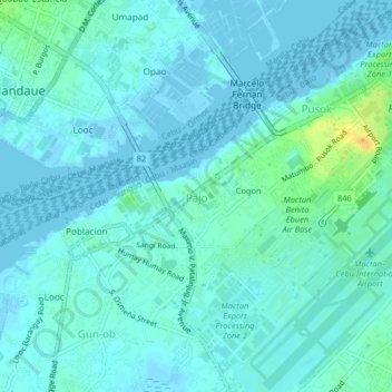
Name: Pajo topographic map, elevation, terrain.

Location: Pajo, Lapu-Lapu, Central Visayas, 6016, Philippines (10.29604 123.94129 10.33604 123.98129)

Average elevation: 5 m

Minimum elevation: -4 m

Maximum elevation: 27 m

Other topographic maps

Click on a map to view its topography, its elevation and its terrain.

Punta Engaño

Philippines > Lapu-Lapu

Average elevation: 2 m

San Vicente

Philippines > Lapu-Lapu

Average elevation: 2 m

Gear up for your next adventure:

🛏️Sleeping Bag - Warm and compact sleeping bags for outdoor camping
🔭Compact Binoculars - Lightweight optics for scouting trails and wildlife
🪑Ultralight Camping Stool - Compact seating for rest stops during long hikes
🧶550 Survival Paracord - Versatile utility cord for emergency repairs and rigging
💧Filtered Water Bottle - Safe drinking water on the go

As an Amazon Associate, this site earns from qualifying purchases at no extra cost to you.