Geolocate

Moti Nagar topographic map

Click on the map to display elevation.

About this map

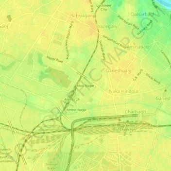
Name: Moti Nagar topographic map, elevation, terrain.

Location: Moti Nagar, Lucknow, Uttar Pradesh, 226004, India (26.81959 80.89333 26.85959 80.93333)

Average elevation: 124 m

Minimum elevation: 106 m

Maximum elevation: 128 m

Other topographic maps

Click on a map to view its topography, its elevation and its terrain.

Kukrail

India > Uttar Pradesh > Lucknow > Lucknow

Average elevation: 120 m

Residency

India > Uttar Pradesh > Lucknow > Lucknow

Average elevation: 119 m

Mayura Park

India > Uttar Pradesh > Lucknow > Lucknow

Average elevation: 119 m

Residency

India > Uttar Pradesh > Lucknow > Lucknow

Average elevation: 119 m

Awadh Kunj Park

India > Uttar Pradesh > Lucknow > Lucknow

Average elevation: 118 m

Gear up for your next adventure:

🥾Lightweight Hiking Boots - Boots for comfort and mobility on long hikes
🥾Hiking Gaiters - Protect legs and shoes from mud, snow, and debris
🧢Hiking Hat - Sun-protective and breathable hats for long treks
🧥Fleece Jacket - Warm and lightweight jacket for layering
🦯Trekking Poles - Reduced impact on joints for steep topographic climbs

As an Amazon Associate, this site earns from qualifying purchases at no extra cost to you.