
Make a donation
Gear up for your next adventure:
As an Amazon Associate, this site earns from qualifying purchases at no extra cost to you.
Burgwenden topographic map
Click on the map to display elevation.
Make a donation
Gear up for your next adventure:
As an Amazon Associate, this site earns from qualifying purchases at no extra cost to you.
Burgwenden
Burgwenden liegt eingebettet zwischen den Höhenzügen Monraburg, Wendenburg (354 m) und Finnberg am südlichen Ausgang eines Passes durch die Schmücke und Hohe Schrecke. Durch den Ort verläuft der Hirschbach.
Make a donation
Gear up for your next adventure:
As an Amazon Associate, this site earns from qualifying purchases at no extra cost to you.
About this map
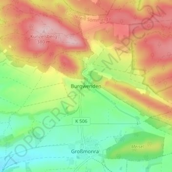
Name: Burgwenden topographic map, elevation, terrain.
Average elevation: 264 m
Minimum elevation: 162 m
Maximum elevation: 380 m
Make a donation
Gear up for your next adventure:
As an Amazon Associate, this site earns from qualifying purchases at no extra cost to you.
Other topographic maps
Click on a map to view its topography, its elevation and its terrain.
Beichlingen
Deutschland > Thüringen > Landkreis Sömmerda > Kölleda
Stadtteil: Kiebitzhöhe
Average elevation: 217 m
Großmonra
Deutschland > Thüringen > Landkreis Sömmerda > Kölleda
Stadtteil: Kiebitzhöhe
Average elevation: 240 m