
Tassullo topographic map
Interactive map
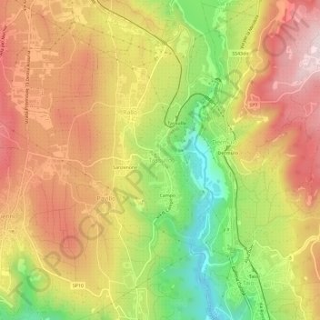
Click on the map to display elevation.
About this map
Name: Tassullo topographic map, elevation, terrain.
Average elevation: 601 m
Minimum elevation: 355 m
Maximum elevation: 803 m
Der Ort liegt etwa 29,5 Kilometer nordnordwestlich von Trient auf einer Höhe von 546 m s.l.m. auf der orographisch rechten Seite des mittleren Nonstals. Nordöstlich von Tassullo liegt die Santa-Giustina-Talsperre. Nördlich in der vom Fluss Noce ausgewaschenen Schlucht liegt das 1995 eingerichtete NATURA 2000 Schutzgebiet Forra di S. Giustina.