
Teterow topographic map
Interactive map
Click on the map to display elevation.
About this map
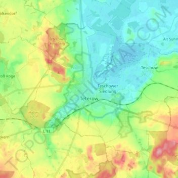
Name: Teterow topographic map, elevation, terrain.
Average elevation: 39 m
Minimum elevation: -1 m
Maximum elevation: 117 m
Other topographic maps
Click on a map to view its topography, its elevation and its terrain.
Längsdamm/Nordpeene/Peene
Allemagne > Mecklembourg-Poméranie-Occidentale > Landkreis Rostock > Alt Sührkow
Längsdamm/Nordpeene/Peene, Alt Sührkow, Mecklenburgische Schweiz, Landkreis Rostock, Mecklembourg-Poméranie-Occidentale, 17166, Allemagne
Average elevation: 8 m