
Thank you for supporting this site ❤️
Make a donation
Make a donation
Gear up for your next adventure:
As an Amazon Associate, this site earns from qualifying purchases at no extra cost to you.
Teixeira topographic map
Click on the map to display elevation.
Thank you for supporting this site ❤️
Make a donation
Make a donation
Gear up for your next adventure:
As an Amazon Associate, this site earns from qualifying purchases at no extra cost to you.
About this map
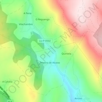
Name: Teixeira topographic map, elevation, terrain.
Location: Teixeira, Baralla, Os Ancares, Lugo, Galiza, 27687, Espanha (42.90523 -7.27717 42.92881 -7.25049)
Average elevation: 688 m
Minimum elevation: 502 m
Maximum elevation: 914 m
Thank you for supporting this site ❤️
Make a donation
Make a donation
Gear up for your next adventure:
As an Amazon Associate, this site earns from qualifying purchases at no extra cost to you.