
Make a donation
Gear up for your next adventure:
As an Amazon Associate, this site earns from qualifying purchases at no extra cost to you.
Puerto Montt topographic map
Click on the map to display elevation.
Make a donation
Gear up for your next adventure:
As an Amazon Associate, this site earns from qualifying purchases at no extra cost to you.
About this map
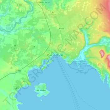
Name: Puerto Montt topographic map, elevation, terrain.
Average elevation: 74 m
Minimum elevation: -2 m
Maximum elevation: 431 m
Make a donation
Gear up for your next adventure:
As an Amazon Associate, this site earns from qualifying purchases at no extra cost to you.
Other topographic maps
Click on a map to view its topography, its elevation and its terrain.
Lago Llanquihue
Chile > Región de Los Lagos > Provincia de Llanquihue
El lago Llanquihue corresponde al segundo mayor lago de Chile tras el lago General Carrera, con una extensión de 860 km². Su profundidad no se conoce con certeza, pero algunas sondas de cordel han arrojado cifras superiores a 350 m. Está a una altitud de 70 m sobre el nivel del mar. Está ubicado en la…
Average elevation: 143 m
Parque Nacional Alerce Andino
Chile > Región de Los Lagos > Provincia de Llanquihue > Puerto Montt
Average elevation: 559 m
Lago Chapo
Chile > Región de Los Lagos > Provincia de Llanquihue > Puerto Montt
Average elevation: 613 m
Make a donation
Gear up for your next adventure:
As an Amazon Associate, this site earns from qualifying purchases at no extra cost to you.
Isla Doña Sebastiana
Chile > Región de Los Lagos > Provincia de Llanquihue > Maullín
Average elevation: 3 m