
Ikwerre topographic map
Interactive map
Click on the map to display elevation.
About this map
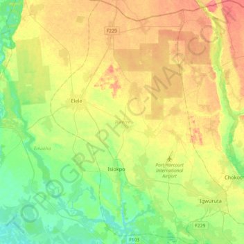
Name: Ikwerre topographic map, elevation, terrain.
Location: Ikwerre, Rivers State, Nigeria (4.89022 6.77579 5.24980 7.03943)
Average elevation: 25 m
Minimum elevation: 0 m
Maximum elevation: 57 m
Other topographic maps
Click on a map to view its topography, its elevation and its terrain.
Obrikom
Nigeria > Rivers State > Ogba/Egbema/Ndoni
Obrikom, Ogba/Egbema/Ndoni, Rivers State, Nigeria
Average elevation: 14 m