Geolocate

Fairfield topographic map

Click on the map to display elevation.

About this map
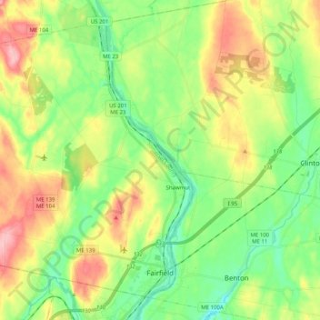
Name: Fairfield topographic map, elevation, terrain.

Location: Fairfield, Somerset County, Maine, United States (44.57732 -69.78027 44.70068 -69.57851)

Average elevation: 64 m

Minimum elevation: 12 m

Maximum elevation: 146 m

Other topographic maps

Click on a map to view its topography, its elevation and its terrain.
Pratt Hill

United States > Maine > Somerset County > Skowhegan

Average elevation: 113 m

Bigelow Hill

United States > Maine > Somerset County > Skowhegan

Average elevation: 158 m

Mackamp

United States > Maine > Somerset County

Average elevation: 395 m

Gray Island

United States > Maine > Somerset County > Solon

Average elevation: 105 m

Norris Brook

United States > Maine > Somerset County

Average elevation: 420 m

Gear up for your next adventure:

💡LED Headlamp - Hands-free illumination for night hiking and camping
🧢Beanie Hat - Keep your head warm in cold weather
🧦Hiking Socks - Moisture-wicking and comfortable socks for long hikes
💧Hydration Bladder - Hands-free hydration solution for long treks
🔥Emergency Fire Starter - Reliable ignition source for all weather conditions

As an Amazon Associate, this site earns from qualifying purchases at no extra cost to you.