
Make a donation
Gear up for your next adventure:
As an Amazon Associate, this site earns from qualifying purchases at no extra cost to you.
Deoghar topographic map
Click on the map to display elevation.
Make a donation
Gear up for your next adventure:
As an Amazon Associate, this site earns from qualifying purchases at no extra cost to you.
About this map
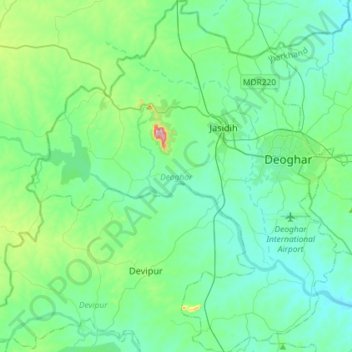
Name: Deoghar topographic map, elevation, terrain.
Location: Deoghar, Deoghar District, Jharkhand, India (24.34495 86.48309 24.60863 86.74766)
Average elevation: 258 m
Minimum elevation: 203 m
Maximum elevation: 519 m
Make a donation
Gear up for your next adventure:
As an Amazon Associate, this site earns from qualifying purchases at no extra cost to you.
Other topographic maps
Click on a map to view its topography, its elevation and its terrain.
Jamshedpur
India > Jharkhand > Golmuri-Cum-Jugsalai
Jamshedpur is situated in the southern end of the state of Jharkhand and is bordered by the states of Odisha and West Bengal. The average elevation of the city is 135 metres while the range is from 129 m to 151 m. Total geographical area of Jamshedpur is 224 km square. Jamshedpur is primarily located in a…
Average elevation: 195 m