
Thank you for supporting this site ❤️
Make a donation
Make a donation
Gear up for your next adventure:
As an Amazon Associate, this site earns from qualifying purchases at no extra cost to you.
Koratagere topographic map
Click on the map to display elevation.
Thank you for supporting this site ❤️
Make a donation
Make a donation
Gear up for your next adventure:
As an Amazon Associate, this site earns from qualifying purchases at no extra cost to you.
Koratagere
Koratagere is a Town in Koratagere Taluk in Tumkur District in Karnataka State. 13°31′N 77°14′E / 13.52°N 77.23°E / 13.52; 77.23. It has an average elevation of 750 metres (2460 feet).
Thank you for supporting this site ❤️
Make a donation
Make a donation
Gear up for your next adventure:
As an Amazon Associate, this site earns from qualifying purchases at no extra cost to you.
About this map
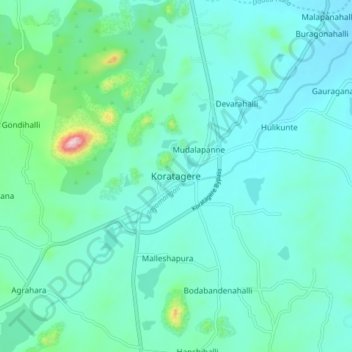
Name: Koratagere topographic map, elevation, terrain.
Average elevation: 780 m
Minimum elevation: 723 m
Maximum elevation: 1,086 m
Thank you for supporting this site ❤️
Make a donation
Make a donation
Gear up for your next adventure:
As an Amazon Associate, this site earns from qualifying purchases at no extra cost to you.