Geolocate

Gorra topographic map

Click on the map to display elevation.

About this map

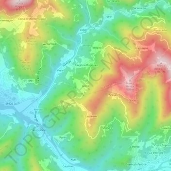
Name: Gorra topographic map, elevation, terrain.

Location: Gorra, Valbrevenna, Genoa, Liguria, 16015, Italy (44.51568 9.00899 44.55568 9.04899)

Average elevation: 593 m

Minimum elevation: 394 m

Maximum elevation: 936 m

Other topographic maps

Click on a map to view its topography, its elevation and its terrain.

Moneglia

Italy > Liguria > Genoa

Average elevation: 154 m

Gear up for your next adventure:

💧Hydration Bladder - Hands-free hydration solution for long treks
🧥Softshell Hiking Jacket - The perfect balance of wind protection and breathability
🥾Hiking Shoes - Durable and comfortable shoes for trail hiking
Lightweight Camping Tent - Portable shelter optimized for Canadian backcountry camping
🥾Trail Hiking Socks - Comfortable socks to prevent blisters and fatigue

As an Amazon Associate, this site earns from qualifying purchases at no extra cost to you.