
Make a donation
Gear up for your next adventure:
As an Amazon Associate, this site earns from qualifying purchases at no extra cost to you.
Wildes Mannle topographic map
Click on the map to display elevation.
Make a donation
Gear up for your next adventure:
As an Amazon Associate, this site earns from qualifying purchases at no extra cost to you.
Wildes Mannle
Inzwischen wurde eine zweite Seilbahn (Sechser-Sessellift "Wildes Mannle"), die ab Stablein bis in etwa 2640 m Höhe führt, in Betrieb genommen. Diese verkürzt den Aufstieg ab Stablein um eine Stunde.
Make a donation
Gear up for your next adventure:
As an Amazon Associate, this site earns from qualifying purchases at no extra cost to you.
About this map
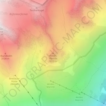
Name: Wildes Mannle topographic map, elevation, terrain.
Average elevation: 2,778 m
Minimum elevation: 1,919 m
Maximum elevation: 3,493 m
Make a donation
Gear up for your next adventure:
As an Amazon Associate, this site earns from qualifying purchases at no extra cost to you.
Other topographic maps
Click on a map to view its topography, its elevation and its terrain.
Ramolhaus
Österreich > Tirol > Bezirk Imst > Gemeinde Sölden
Der Aufstieg erfolgt von Obergurgl (1927 m) auf dem bezeichneten Weitwanderweg Nr. 902 in einer Gehzeit von vier Stunden. In Obergurgl wird zunächst die Gurgler Ache in südwestlicher Richtung überquert. Der Weg führt zunächst am westlichen Talhang in zwei Kehren empor, quert dann einen Bach und führt…
Average elevation: 2,855 m