Geolocate

Pag-asa topographic map

Click on the map to display elevation.

About this map

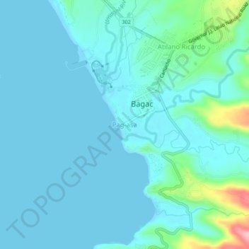
Name: Pag-asa topographic map, elevation, terrain.

Location: Pag-asa, Bagac, Bataan, Central Luzon, 2107, Philippines (14.57338 120.36939 14.61338 120.40939)

Average elevation: 19 m

Minimum elevation: 0 m

Maximum elevation: 141 m

Gear up for your next adventure:

🧦Thermal Socks - Warm socks for winter hiking or camping
🏃Hydration Running Vest - Carry water and maps close to your body for speed
🧢Beanie Hat - Keep your head warm in cold weather
🔦LED Headlamp - Hands-free lighting for early morning starts or late finishes
🥾Waterproof Hiking Boots - Boots keeping your feet dry in wet conditions

As an Amazon Associate, this site earns from qualifying purchases at no extra cost to you.