
Garsdale topographic map
Interactive map
Click on the map to display elevation.
About this map
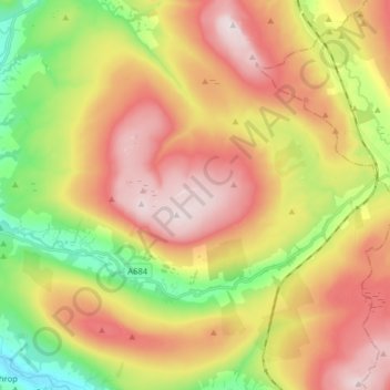
Name: Garsdale topographic map, elevation, terrain.
Location: Garsdale, Westmorland and Furness, Angleterre, Royaume-Uni (54.28921 -2.46895 54.35989 -2.30983)
Average elevation: 406 m
Minimum elevation: 126 m
Maximum elevation: 684 m
Other topographic maps
Click on a map to view its topography, its elevation and its terrain.
Kendal
Royaume-Uni > Angleterre > Westmorland and Furness
Kendal, Westmorland and Furness, Angleterre, Royaume-Uni
Average elevation: 112 m
Grayrigg
Royaume-Uni > Angleterre > Westmorland and Furness
Grayrigg, Westmorland and Furness, Angleterre, Royaume-Uni
Average elevation: 257 m