
Thank you for supporting this site ❤️
Make a donation
Make a donation
Gear up for your next adventure:
As an Amazon Associate, this site earns from qualifying purchases at no extra cost to you.
Sorgaçosa topographic map
Click on the map to display elevation.
Thank you for supporting this site ❤️
Make a donation
Make a donation
Gear up for your next adventure:
As an Amazon Associate, this site earns from qualifying purchases at no extra cost to you.
About this map
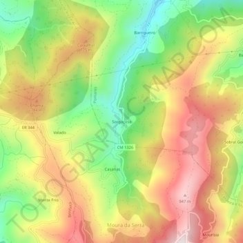
Name: Sorgaçosa topographic map, elevation, terrain.
Location: Sorgaçosa, Pomares, Arganil, Coimbra, 3305-259, Portugal (40.22058 -7.91609 40.26058 -7.87609)
Average elevation: 650 m
Minimum elevation: 321 m
Maximum elevation: 976 m
Thank you for supporting this site ❤️
Make a donation
Make a donation
Gear up for your next adventure:
As an Amazon Associate, this site earns from qualifying purchases at no extra cost to you.
Other topographic maps
Click on a map to view its topography, its elevation and its terrain.
Piscina Fluvial de Soito da Ruiva
Portugal > Coimbra > Pomares > Soito da Ruiva
Average elevation: 858 m