
Thank you for supporting this site ❤️
Make a donation
Make a donation
Gear up for your next adventure:
As an Amazon Associate, this site earns from qualifying purchases at no extra cost to you.
Sērene topographic map
Click on the map to display elevation.
Thank you for supporting this site ❤️
Make a donation
Make a donation
Gear up for your next adventure:
As an Amazon Associate, this site earns from qualifying purchases at no extra cost to you.
About this map
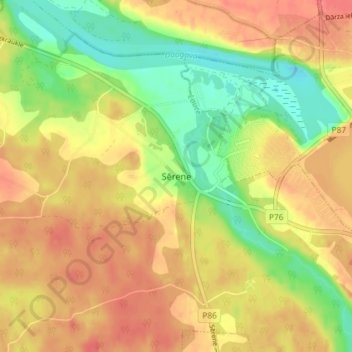
Name: Sērene topographic map, elevation, terrain.
Location: Sērene, Sērenes pagasts, Aizkraukles novads, LV-5123, Latvia (56.55780 25.18564 56.59780 25.22564)
Average elevation: 64 m
Minimum elevation: 29 m
Maximum elevation: 90 m
Thank you for supporting this site ❤️
Make a donation
Make a donation
Gear up for your next adventure:
As an Amazon Associate, this site earns from qualifying purchases at no extra cost to you.