Geolocate

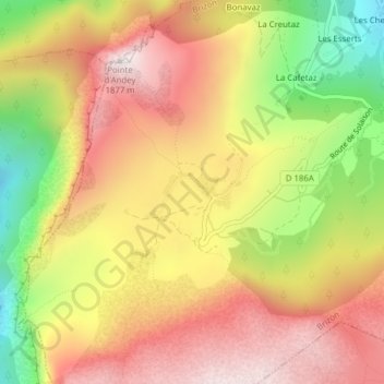
Solaison topographic map

Click on the map to display elevation.

Solaison

Le col de Solaison ou plateau de Solaison est un col de France situé en Haute-Savoie, dans le massif des Bornes, à une altitude moyenne de 1 500 mètres, sur le territoire de la commune de Brizon.

Wikipedia (CC-BY-SA 3.0)

About this map

Name: Solaison topographic map, elevation, terrain.

Location: Solaison, Brizon, Bonneville, Haute-Savoie, Auvergne-Rhône-Alpes, France métropolitaine, 74130, France (46.02362 6.41535 46.04362 6.43535)

Average elevation: 1,490 m

Minimum elevation: 1,017 m

Maximum elevation: 1,857 m

Other topographic maps

Click on a map to view its topography, its elevation and its terrain.
74130

France > Auvergne-Rhône-Alpes > Haute-Savoie > Brizon

Average elevation: 1,085 m

Gear up for your next adventure:

🧥Ultralight Puffy Jacket - Maximum warmth that packs down to the size of an orange
🦟Insect Repellent - Keep mosquitoes and black flies away in wooded areas
🗺️Topographic Maps - Detailed maps to explore trails, mountains, and wilderness areas
🥾Approach Shoes - Shoes designed for climbing approaches and rugged trails
🌬️Windproof Camp Stove - Efficient cooking even on exposed mountain peaks

As an Amazon Associate, this site earns from qualifying purchases at no extra cost to you.