Geolocate

Aprilia topographic map

Click on the map to display elevation.

About this map

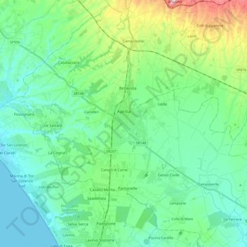
Name: Aprilia topographic map, elevation, terrain.

Location: Aprilia, Latina, Lazio, 04011, Italy (41.49783 12.53016 41.67193 12.77175)

Average elevation: 73 m

Minimum elevation: 0 m

Maximum elevation: 328 m

Other topographic maps

Click on a map to view its topography, its elevation and its terrain.

Campoleone Scalo

Italy > Lazio > Latina > Aprilia

Average elevation: 124 m

Gear up for your next adventure:

Camping Tent - Weather-resistant tents suitable for 2 to 6 people
🩹Compact First Aid Kit - Pre-packed essentials for common trail injuries
🧣Merino Neck Gaiter - Protects against wind, sun, and cold at high altitudes
💧Collapsible Water Bottle - Space-saving water bottle for outdoor activities
🧥Insulated Jacket - Keep warm in cold outdoor conditions

As an Amazon Associate, this site earns from qualifying purchases at no extra cost to you.