
Halti topographic map
Interactive map
Click on the map to display elevation.
About this map
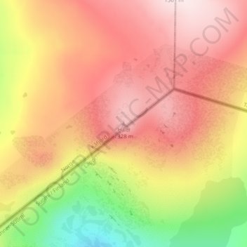
Name: Halti topographic map, elevation, terrain.
Location: Halti, Kåfjord, Troms og Finnmark, Norway (69.30801 21.26327 69.30811 21.26337)
Average elevation: 1,192 m
Minimum elevation: 950 m
Maximum elevation: 1,358 m
Halti (Finnish: Halti, rarely Haltiatunturi, Northern Sami: Háldičohkka, Swedish: Haldefjäll) is a fell at the border between Norway and Finland. The peak (elevation 1,365 m (4,478 ft)) of the fell, called Ráisduattarháldi, is in Norway, on the border between the municipalities of Nordreisa and Gáivuotna–Kåfjord, about one kilometre (5⁄8 mile) north of the border with Finland. The highest point of the fell on the Finnish side is at 1,324 m (4,344 ft) above sea level, and thus the highest point in the country. The Finnish side of Halti belongs to the municipality of Enontekiö in the province of Lapland.
Other topographic maps
Click on a map to view its topography, its elevation and its terrain.
South Varanki
South Varanki, Troms og Finnmark, Norway
Average elevation: 150 m
Nord-Lenangen
Nord-Lenangen, Lyngen, Troms og Finnmark, 9068, Norway
Average elevation: 52 m
Lyngseidet
Lyngseidet, Lyngen, Troms og Finnmark, 9060, Norway
Average elevation: 181 m
Stordalen
Norway > Troms og Finnmark > Tromsø > Stordalen
Stordalen, Tromsø, Troms og Finnmark, Norway
Average elevation: 150 m