
Make a donation
Gear up for your next adventure:
As an Amazon Associate, this site earns from qualifying purchases at no extra cost to you.
Thousand Oaks topographic map
Click on the map to display elevation.
Make a donation
Gear up for your next adventure:
As an Amazon Associate, this site earns from qualifying purchases at no extra cost to you.
About this map
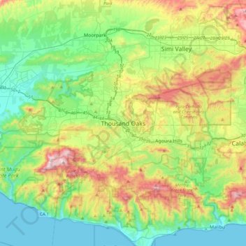
Name: Thousand Oaks topographic map, elevation, terrain.
Average elevation: 288 m
Minimum elevation: 0 m
Maximum elevation: 918 m
Make a donation
Gear up for your next adventure:
As an Amazon Associate, this site earns from qualifying purchases at no extra cost to you.
Other topographic maps
Click on a map to view its topography, its elevation and its terrain.
Thousand Oaks
United States > California > Ventura County > Thousand Oaks
The northern parts consist of mountainous terrain in the Simi Hills, Conejo Mountains and Mount Clef Ridge. Narrow canyons such as Hill Canyon cut through the steeper mountainous areas. Conejo Mountain and Conejo Grade are found in westernmost Newbury Park, while the southernmost parts of Thousand Oaks are…
Average elevation: 303 m
Santa Monica Mountains
United States > California > Ventura County > Thousand Oaks
On January 17, 2007, an unusually cold storm brought snow in the Santa Monica Mountains. The hills above Malibu picked up three inches (eight centimeters) of snow - the first measurable snow in fifty years. Snow was reported on Boney Peak in the winter of 2005; and in March 2006, snow also fell on the summit…
Average elevation: 171 m