
Make a donation
Gear up for your next adventure:
As an Amazon Associate, this site earns from qualifying purchases at no extra cost to you.
Akto County topographic map
Click on the map to display elevation.
Make a donation
Gear up for your next adventure:
As an Amazon Associate, this site earns from qualifying purchases at no extra cost to you.
Akto County
Akto County is located in the three major geographic regions of the Pamirs, the northern slopes of the Kunlun Mountains and the oasis on the western edge of the Tarim Basin. The landform is dominated by mountains, with the mountainous area accounting for 96.39% of the total area of the county, and the mountainous areas generally at an altitude of 4,000-5,000 meters. The Kungay Mountain (昆盖山) in the northwest is the boundary mountain of the county with Wuqia County, with an elevation of 5,753.7 meters. The Sarikol Range (萨雷阔勒岭) in the southwest is more than 4,500 meters above sea level; the highest peak of Kongur Tagh (公格尔山) in the central part is 7,719 meters above sea level, the peak of Kongur Tiube (公格尔九别峰) is 7,530 meters high above sea level, and the peak of Muztagh Ata (慕士塔格峰) is 7,541 meters high. There are 66 snow-capped peaks in the territory, including 36 large ice peaks. The mountaintops have snow all the year round, and there are glaciers of different sizes around the peaks. The landform features severe drought and erosion, bare mountain and sparse vegetation. Due to the different rock types of the mountains, they are gray, black, yellow, red and white bare mountains. Many mountain bodies are red, gray, yellow and other colors.
Make a donation
Gear up for your next adventure:
As an Amazon Associate, this site earns from qualifying purchases at no extra cost to you.
About this map
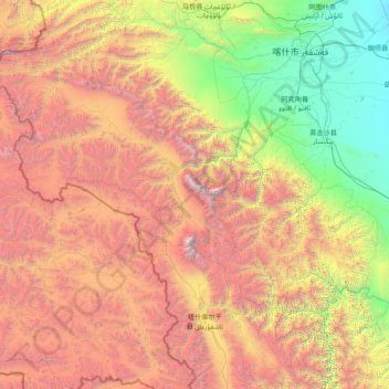
Name: Akto County topographic map, elevation, terrain.
Average elevation: 3,378 m
Minimum elevation: 1,201 m
Maximum elevation: 7,558 m
Make a donation
Gear up for your next adventure:
As an Amazon Associate, this site earns from qualifying purchases at no extra cost to you.