Geolocate

Raquina topographic map

Click on the map to display elevation.

About this map

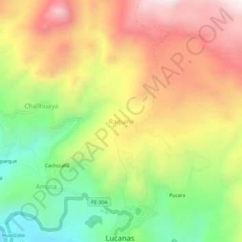
Name: Raquina topographic map, elevation, terrain.

Location: Raquina, Lucanas, Provincia de Lucanas, Ayacucho, Perú (-14.62298 -74.25319 -14.58298 -74.21319)

Average elevation: 3,549 m

Minimum elevation: 3,121 m

Maximum elevation: 3,985 m

Gear up for your next adventure:

🏕️Camping Hammock - Integrated protection for sleeping between trees
🔋Lithium AA Batteries - Long-lasting power that performs in extreme cold
👟Leg Gaiters - Keep debris, mud, and snow out of your boots
🧤Thermal Hiking Gloves - Grip-enhanced gloves for cold-weather altitude trekking
🛏️Camping Sleeping Mat - Comfortable mats for sleeping outdoors

As an Amazon Associate, this site earns from qualifying purchases at no extra cost to you.