Geolocate

Greenville topographic map

Click on the map to display elevation.

About this map

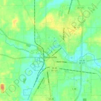
Name: Greenville topographic map, elevation, terrain.

Location: Greenville, Darke County, Ohio, 45331, United States (40.07403 -84.64757 40.13935 -84.58181)

Average elevation: 317 m

Minimum elevation: 304 m

Maximum elevation: 337 m

Other topographic maps

Click on a map to view its topography, its elevation and its terrain.

Coletown

United States > Ohio > Darke County

Average elevation: 322 m

Pikeville

United States > Ohio > Darke County

Average elevation: 311 m

Gear up for your next adventure:

🔭Compact Binoculars - Lightweight optics for scouting trails and wildlife
🧼Biodegradable Camp Soap - Environmentally friendly cleaning for gear and body
🥘Camping Cookware Set - Compact nesting pots and pans for trail cooking
🩹Compact First Aid Kit - Pre-packed essentials for common trail injuries
🚲Bike Repair Kit - Essential tools for on-trail mechanical issues

As an Amazon Associate, this site earns from qualifying purchases at no extra cost to you.