Geolocate

Siling Bata topographic map

Click on the map to display elevation.

About this map

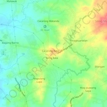
Name: Siling Bata topographic map, elevation, terrain.

Location: Siling Bata, Bulacan, Central Luzon, 3012, Philippines (14.87195 120.94978 14.91195 120.98978)

Average elevation: 47 m

Minimum elevation: 20 m

Maximum elevation: 90 m

Gear up for your next adventure:

🏃Hydration Running Vest - Carry water and maps close to your body for speed
Tent Footprint - Protect tent floor and increase durability
🛰️Satellite Messenger - Emergency communication for areas with no cell service
🌡️Emergency Mylar Blankets - Compact thermal protection for unexpected nights outdoors
💡LED Camping Lantern - Illuminate your campsite with long-lasting lanterns

As an Amazon Associate, this site earns from qualifying purchases at no extra cost to you.