Geolocate

Sivasagar topographic map

Click on the map to display elevation.

Sivasagar

Sivasagar is located at 26°59′20″N 94°38′20″E / 26.9889°N 94.639°E / 26.9889; 94.639. It has an average elevation of 86.6 meters above sea level.

Wikipedia (CC-BY-SA 3.0)

About this map

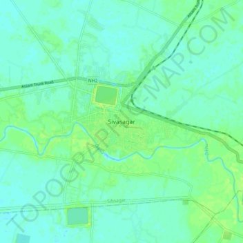
Name: Sivasagar topographic map, elevation, terrain.

Location: Sivasagar, Sibsagar, Sivasagar, Assam, 785600, India (26.94349 94.59942 27.02349 94.67942)

Average elevation: 93 m

Minimum elevation: 88 m

Maximum elevation: 102 m

Gear up for your next adventure:

🕯️Camping Lantern - Illuminates your entire campsite with high-efficiency LEDs
💡Solar Camping Lamp - Eco-friendly lighting for campsites
🥾Lightweight Hiking Boots - Boots for comfort and mobility on long hikes
🏃Hydration Running Vest - Carry water and maps close to your body for speed
🔦LED Headlamp - Hands-free lighting for early morning starts or late finishes

As an Amazon Associate, this site earns from qualifying purchases at no extra cost to you.