Geolocate

Ayala topographic map

Click on the map to display elevation.

About this map

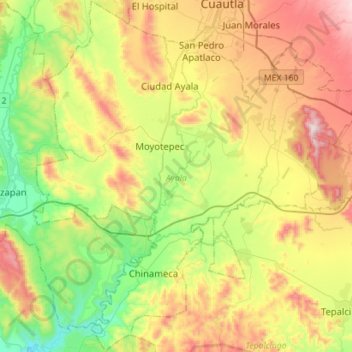
Name: Ayala topographic map, elevation, terrain.

Location: Ayala, Morelos, Mexico (18.56417 -99.09465 18.83093 -98.83578)

Average elevation: 1,210 m

Minimum elevation: 860 m

Maximum elevation: 1,715 m

Other topographic maps

Click on a map to view its topography, its elevation and its terrain.

San Pedro Apatlaco

Mexico > Morelos > Ayala

Average elevation: 1,275 m

Anenecuilco

Mexico > Morelos > Ayala

Average elevation: 1,263 m

Gear up for your next adventure:

🔋Solar Power Bank - Keep your GPS and devices charged during long outdoor trips
🧤Thermal Hiking Gloves - Grip-enhanced gloves for cold-weather altitude trekking
💡Solar Camping Lamp - Eco-friendly lighting for campsites
🥾Waterproof Hiking Boots - Boots keeping your feet dry in wet conditions
🧦Outdoor Socks - Durable socks designed for hiking and outdoor sports

As an Amazon Associate, this site earns from qualifying purchases at no extra cost to you.