
Make a donation
Gear up for your next adventure:
As an Amazon Associate, this site earns from qualifying purchases at no extra cost to you.
Oeventrop topographic map
Click on the map to display elevation.
Make a donation
Gear up for your next adventure:
As an Amazon Associate, this site earns from qualifying purchases at no extra cost to you.
About this map
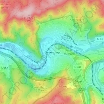
Name: Oeventrop topographic map, elevation, terrain.
Average elevation: 287 m
Minimum elevation: 198 m
Maximum elevation: 428 m
Make a donation
Gear up for your next adventure:
As an Amazon Associate, this site earns from qualifying purchases at no extra cost to you.
Other topographic maps
Click on a map to view its topography, its elevation and its terrain.
Bruchhausen
Deutschland > Nordrhein-Westfalen > Hochsauerlandkreis > Arnsberg
Average elevation: 206 m
59823
Deutschland > Nordrhein-Westfalen > Hochsauerlandkreis > Arnsberg > Oeventrop
Average elevation: 317 m
Make a donation
Gear up for your next adventure:
As an Amazon Associate, this site earns from qualifying purchases at no extra cost to you.
Niedereimer
Deutschland > Nordrhein-Westfalen > Hochsauerlandkreis > Arnsberg
Ein Naturdenkmal, das auch Aufnahme in das Dorfwappen fand, war eine angeblich mehr als tausend Jahre alte dicke Eiche, die noch zu Beginn des 20. Jahrhunderts die drittgrößte Eiche im deutschen Kaiserreich war. In Manneshöhe hatte sie einen Umfang von neun Metern. Der Baum wurde 1853 von König Friedrich…
Average elevation: 249 m
Haarsche Siepen
Deutschland > Nordrhein-Westfalen > Hochsauerlandkreis > Arnsberg
Average elevation: 328 m
Make a donation
Gear up for your next adventure:
As an Amazon Associate, this site earns from qualifying purchases at no extra cost to you.
59757
Deutschland > Nordrhein-Westfalen > Hochsauerlandkreis > Arnsberg > Herdringen
Average elevation: 259 m