
Make a donation
Gear up for your next adventure:
As an Amazon Associate, this site earns from qualifying purchases at no extra cost to you.
Gourdon topographic map
Click on the map to display elevation.
Make a donation
Gear up for your next adventure:
As an Amazon Associate, this site earns from qualifying purchases at no extra cost to you.
About this map
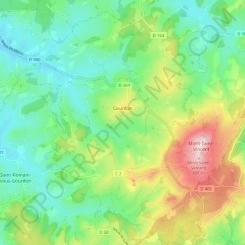
Name: Gourdon topographic map, elevation, terrain.
Average elevation: 398 m
Minimum elevation: 298 m
Maximum elevation: 601 m
Make a donation
Gear up for your next adventure:
As an Amazon Associate, this site earns from qualifying purchases at no extra cost to you.
Other topographic maps
Click on a map to view its topography, its elevation and its terrain.
La Croix
France > Bourgogne – Franche-Comté > Saône-et-Loire > Saint-Sernin-du-Bois
Average elevation: 445 m
Make a donation
Gear up for your next adventure:
As an Amazon Associate, this site earns from qualifying purchases at no extra cost to you.
Dardy
France > Bourgogne – Franche-Comté > Saône-et-Loire > Saint-Pierre-le-Vieux
Average elevation: 486 m
Verdin
France > Bourgogne – Franche-Comté > Saône-et-Loire > Montagny-près-Louhans
Average elevation: 199 m
Château d'Estours
France > Bourgogne – Franche-Comté > Saône-et-Loire > Crêches-sur-Saône > Estours
Average elevation: 183 m
Les Creux Bréçons
France > Bourgogne – Franche-Comté > Saône-et-Loire > Toulon-sur-Arroux
Average elevation: 284 m
Make a donation
Gear up for your next adventure:
As an Amazon Associate, this site earns from qualifying purchases at no extra cost to you.
La Ferdière du Bas
France > Bourgogne – Franche-Comté > Saône-et-Loire > Navour-sur-Grosne
Average elevation: 363 m
Les Grandes Vignes
France > Bourgogne – Franche-Comté > Saône-et-Loire > Prissé
Average elevation: 244 m