Geolocate

Solano topographic map

Click on the map to display elevation.

About this map

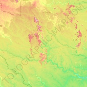
Name: Solano topographic map, elevation, terrain.

Location: Solano, Caquetá, RAP Amazonía, Colombia (-0.70656 -75.51631 1.18830 -71.25310)

Average elevation: 196 m

Minimum elevation: 72 m

Maximum elevation: 777 m

Other topographic maps

Click on a map to view its topography, its elevation and its terrain.

Panama

Colombia > Caquetá > Cartagena del Chairá

Average elevation: 206 m

Macuje

Colombia > Caquetá > Solano

Average elevation: 221 m

Villa Lobos

Colombia > Caquetá

Average elevation: 248 m

Gear up for your next adventure:

🧣Evaporative Cooling Towel - Beat the heat during intense summer climbs
🥤Collapsible Travel Cup - Saves space and weight in your mess kit
🥾Hiking Leggings - Comfortable leggings for outdoor activities
👟Trail Running Shoes - Agile footwear for fast-paced topographic exploration
🦶Hiking Shoe Insoles - Added support for high arches and long days on feet

As an Amazon Associate, this site earns from qualifying purchases at no extra cost to you.