
Make a donation
Gear up for your next adventure:
As an Amazon Associate, this site earns from qualifying purchases at no extra cost to you.
Igman topographic map
Click on the map to display elevation.
Make a donation
Gear up for your next adventure:
As an Amazon Associate, this site earns from qualifying purchases at no extra cost to you.
Igman
Igman (Serbian Cyrillic: Игман, pronounced [îɡman]) is a mountain plateau in central Bosnia and Herzegovina. Geologically, Igman is part of the Dinaric Alps and formed largely of secondary and tertiary sedimentary rock, mostly Limestone. It is located southwest of Sarajevo, bordering the Bjelašnica range in the south and west, Hadžići and Ilidža in the north, and the river Željeznica in the east. Igman's highest point, Crni vrh, west of the Malo Polje road, at an altitude of 1,510 metres (4,954 feet), the homonym highest elevation on the east side of this road reaches an elevation of 1,502 metres (4,928 feet). Most of Igman is covered with mixed forest with local pastures (f.i.: Veliko Polje: Large Field, Malo Polje: Small Field). Igman was the location of the lowest recorded temperature in the region, −43 °C (−45 °F). Igman was the site of extensive combat during the 1992-95 Siege of Sarajevo and certain areas, in particular the surroundings of former front lines, constitute a high mine risk.
Make a donation
Gear up for your next adventure:
As an Amazon Associate, this site earns from qualifying purchases at no extra cost to you.
About this map
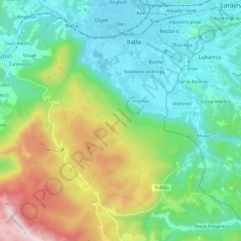
Name: Igman topographic map, elevation, terrain.
Average elevation: 895 m
Minimum elevation: 483 m
Maximum elevation: 2,040 m
Make a donation
Gear up for your next adventure:
As an Amazon Associate, this site earns from qualifying purchases at no extra cost to you.