
Thank you for supporting this site ❤️
Make a donation
Make a donation
Gear up for your next adventure:
As an Amazon Associate, this site earns from qualifying purchases at no extra cost to you.
Brittnau topographic map
Click on the map to display elevation.
Thank you for supporting this site ❤️
Make a donation
Make a donation
Gear up for your next adventure:
As an Amazon Associate, this site earns from qualifying purchases at no extra cost to you.
About this map
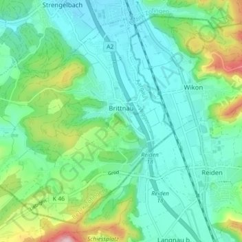
Name: Brittnau topographic map, elevation, terrain.
Location: Brittnau, Bezirk Zofingen, Aargau, 4805, Switzerland (47.23590 7.89153 47.27631 7.96188)
Average elevation: 493 m
Minimum elevation: 430 m
Maximum elevation: 687 m
Thank you for supporting this site ❤️
Make a donation
Make a donation
Gear up for your next adventure:
As an Amazon Associate, this site earns from qualifying purchases at no extra cost to you.