Geolocate

Schnaidberg topographic map

Click on the map to display elevation.

About this map

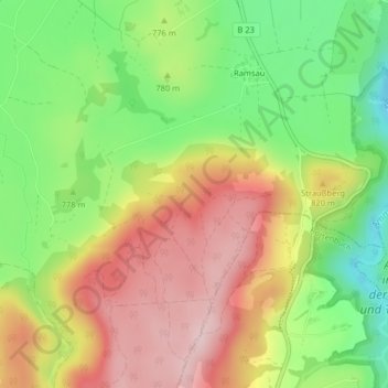
Name: Schnaidberg topographic map, elevation, terrain.

Location: Schnaidberg, Peiting, Landkreis Weilheim-Schongau, Bayern, 86971, Deutschland (47.75427 10.92078 47.77427 10.94078)

Average elevation: 782 m

Minimum elevation: 656 m

Maximum elevation: 911 m

Other topographic maps

Click on a map to view its topography, its elevation and its terrain.

Gear up for your next adventure:

🚲Bike Repair Kit - Essential tools for on-trail mechanical issues
🎒Backpack Rain Cover - External shield to keep your entire pack dry
🧦Hiking Liner Socks - Thin base layer to prevent friction and blisters
🧢Sun Hat - Wide-brim hat for sun protection
💡Portable Camping Lamp - Rechargeable lamp for campsite lighting

As an Amazon Associate, this site earns from qualifying purchases at no extra cost to you.