
Thank you for supporting this site ❤️
Make a donation
Make a donation
Gear up for your next adventure:
As an Amazon Associate, this site earns from qualifying purchases at no extra cost to you.
Mankim topographic map
Click on the map to display elevation.
Thank you for supporting this site ❤️
Make a donation
Make a donation
Gear up for your next adventure:
As an Amazon Associate, this site earns from qualifying purchases at no extra cost to you.
About this map
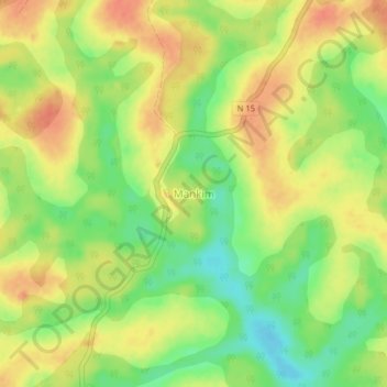
Name: Mankim topographic map, elevation, terrain.
Location: Mankim, Yoko, Mbam-et-Kim, Centre, Cameroon (5.00064 11.98672 5.04064 12.02672)
Average elevation: 604 m
Minimum elevation: 578 m
Maximum elevation: 623 m
Thank you for supporting this site ❤️
Make a donation
Make a donation
Gear up for your next adventure:
As an Amazon Associate, this site earns from qualifying purchases at no extra cost to you.