Geolocate

Kaihere topographic map

Click on the map to display elevation.

About this map

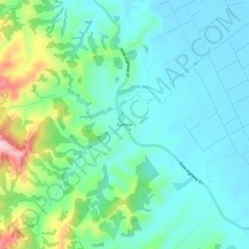
Name: Kaihere topographic map, elevation, terrain.

Location: Kaihere, Hauraki District, Waikato, New Zealand (-37.39198 175.39910 -37.35198 175.43910)

Average elevation: 69 m

Minimum elevation: 9 m

Maximum elevation: 265 m

Other topographic maps

Click on a map to view its topography, its elevation and its terrain.

Piako River

New Zealand > Waikato > Hauraki District

Average elevation: 4 m

Ohinemuri River

New Zealand > Waikato > Hauraki District

Average elevation: 197 m

Gear up for your next adventure:

🥾Trail Hiking Boots - Supportive boots for rough trails
🥾Trail Running Boots - Durable shoes designed for trail running
🧦Thermal Socks - Warm socks for winter hiking or camping
🥾Durable Hiking Shoes - Long-lasting shoes for frequent hiking
🩹Moleskin Blister Pads - Direct protection for painful foot pressure points

As an Amazon Associate, this site earns from qualifying purchases at no extra cost to you.