Geolocate

Meru North topographic map

Click on the map to display elevation.

About this map

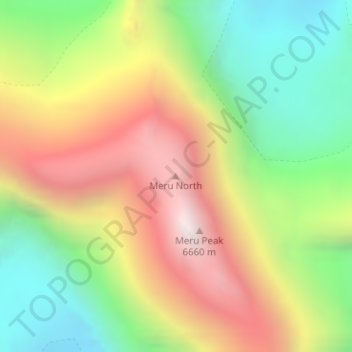
Name: Meru North topographic map, elevation, terrain.

Location: Meru North, Bhatwari, Uttarkashi, Uttarakhand, India (30.87137 79.03168 30.87147 79.03178)

Average elevation: 5,744 m

Minimum elevation: 5,026 m

Maximum elevation: 6,607 m

Other topographic maps

Click on a map to view its topography, its elevation and its terrain.

Kyarkoti Lake

India > Uttarakhand > Bhatwari

Average elevation: 4,043 m

Harsil

India > Uttarakhand > Bhatwari

Average elevation: 2,761 m

Pari Maatri Taal

India > Uttarakhand > Bhatwari

Average elevation: 4,443 m

Kedar Tal

India > Uttarakhand > Bhatwari

Average elevation: 4,814 m

Harsil

India > Uttarakhand > Bhatwari

Average elevation: 2,761 m

Dayara Bugyal

India > Uttarakhand > Bhatwari

Average elevation: 3,451 m

Kalindi Khal Area

India > Uttarakhand > Bhatwari

Average elevation: 5,857 m

Gangotri Glacier

India > Uttarakhand > Bhatwari

Average elevation: 5,259 m

Kedar Tal

India > Uttarakhand > Bhatwari

Average elevation: 4,814 m

Gangotri Glacier

India > Uttarakhand > Bhatwari

Average elevation: 5,259 m

Gear up for your next adventure:

🧦Thermal Socks - Warm socks for winter hiking or camping
🧢Hiking Hat - Sun-protective and breathable hats for long treks
🔋Solar Power Bank - Keep your GPS and devices charged during long outdoor trips
🧢Outdoor Visor - Breathable visor for sunny hikes
👟Leg Gaiters - Keep debris, mud, and snow out of your boots

As an Amazon Associate, this site earns from qualifying purchases at no extra cost to you.