Geolocate

Ndanda topographic map

Click on the map to display elevation.

About this map

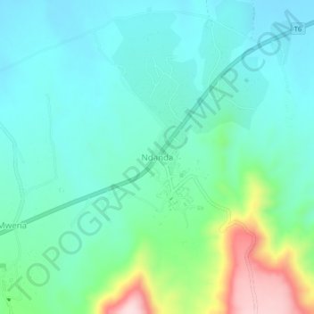
Name: Ndanda topographic map, elevation, terrain.

Location: Ndanda, Masasi, Mtwara Region, Coastal Zone, Tanzania (-10.51728 39.00708 -10.47728 39.04708)

Average elevation: 319 m

Minimum elevation: 249 m

Maximum elevation: 554 m

Other topographic maps

Click on a map to view its topography, its elevation and its terrain.

Tandahimba

Tanzania > Mtwara Region

Average elevation: 333 m

Masasi

Tanzania > Mtwara Region

Average elevation: 345 m

Gear up for your next adventure:

🧥Thermal Layer - Insulating layer for cold outdoor conditions
🥾Trekking Poles - Adjustable trekking poles to reduce knee stress and improve stability
🧦Outdoor Socks - Durable socks designed for hiking and outdoor sports
💡LED Headlamp - Hands-free illumination for night hiking and camping
🥾Lightweight Hiking Boots - Boots for comfort and mobility on long hikes

As an Amazon Associate, this site earns from qualifying purchases at no extra cost to you.