Geolocate

Sector 5 topographic map

Click on the map to display elevation.

About this map

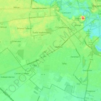
Name: Sector 5 topographic map, elevation, terrain.

Location: Sector 5, Bucharest, Romania (44.36920 25.99620 44.43820 26.09829)

Average elevation: 84 m

Minimum elevation: 64 m

Maximum elevation: 118 m

Other topographic maps

Click on a map to view its topography, its elevation and its terrain.

Parcul Circului

Romania > Bucharest

Average elevation: 85 m

Dealul Arsenalului

Romania > Bucharest

Average elevation: 84 m

Gear up for your next adventure:

🥾Mountain Trail Shoes - High-traction shoes for mountain trails
Bushcraft Tarp - Versatile emergency shelter or gear protection
💧Hydration Bladder - Hands-free hydration solution for long treks
🎒Backpack Rain Cover - External shield to keep your entire pack dry
🧣Merino Neck Gaiter - Protects against wind, sun, and cold at high altitudes

As an Amazon Associate, this site earns from qualifying purchases at no extra cost to you.