
Thank you for supporting this site ❤️
Make a donation
Make a donation
Gear up for your next adventure:
As an Amazon Associate, this site earns from qualifying purchases at no extra cost to you.
Schmücke topographic map
Click on the map to display elevation.
Thank you for supporting this site ❤️
Make a donation
Make a donation
Gear up for your next adventure:
As an Amazon Associate, this site earns from qualifying purchases at no extra cost to you.
About this map
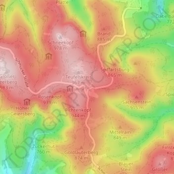
Name: Schmücke topographic map, elevation, terrain.
Location: Schmücke, Gehlberg, Suhl, Thuringia, 98528, Germany (50.63463 10.75371 50.67463 10.79371)
Average elevation: 817 m
Minimum elevation: 588 m
Maximum elevation: 980 m
Thank you for supporting this site ❤️
Make a donation
Make a donation
Gear up for your next adventure:
As an Amazon Associate, this site earns from qualifying purchases at no extra cost to you.