
Thank you for supporting this site ❤️
Make a donation
Make a donation
Gear up for your next adventure:
As an Amazon Associate, this site earns from qualifying purchases at no extra cost to you.
Askas topographic map
Click on the map to display elevation.
Thank you for supporting this site ❤️
Make a donation
Make a donation
Gear up for your next adventure:
As an Amazon Associate, this site earns from qualifying purchases at no extra cost to you.
About this map
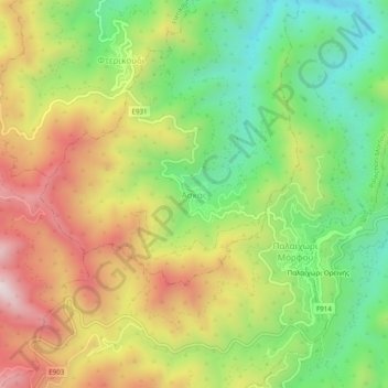
Name: Askas topographic map, elevation, terrain.
Location: Askas, Madari-Papoutsa, Nicosia District, Cyprus (34.90963 33.05825 34.94963 33.09825)
Average elevation: 1,008 m
Minimum elevation: 681 m
Maximum elevation: 1,407 m
Thank you for supporting this site ❤️
Make a donation
Make a donation
Gear up for your next adventure:
As an Amazon Associate, this site earns from qualifying purchases at no extra cost to you.