
Thank you for supporting this site ❤️
Make a donation
Make a donation
Gear up for your next adventure:
As an Amazon Associate, this site earns from qualifying purchases at no extra cost to you.
Uğurlu topographic map
Click on the map to display elevation.
Thank you for supporting this site ❤️
Make a donation
Make a donation
Gear up for your next adventure:
As an Amazon Associate, this site earns from qualifying purchases at no extra cost to you.
About this map
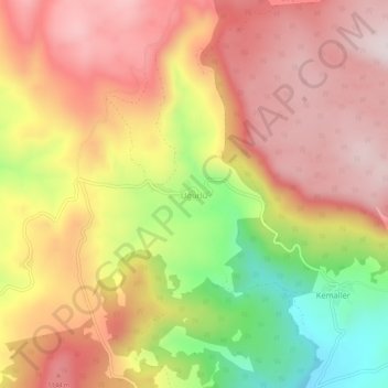
Name: Uğurlu topographic map, elevation, terrain.
Location: Uğurlu, Taraklı, Sakarya, Marmara Region, Turkey (40.45496 30.53387 40.49496 30.57387)
Average elevation: 995 m
Minimum elevation: 665 m
Maximum elevation: 1,219 m
Thank you for supporting this site ❤️
Make a donation
Make a donation
Gear up for your next adventure:
As an Amazon Associate, this site earns from qualifying purchases at no extra cost to you.