
Nuptse I topographic map
Interactive map
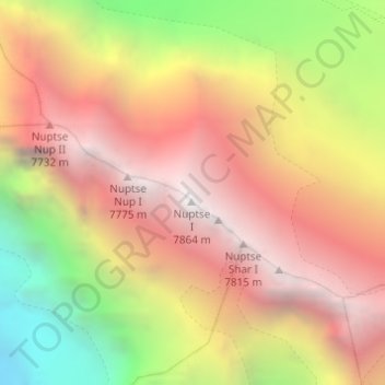
Click on the map to display elevation.
About this map
Name: Nuptse I topographic map, elevation, terrain.
Average elevation: 6,836 m
Minimum elevation: 5,460 m
Maximum elevation: 7,832 m
Other topographic maps
Click on a map to view its topography, its elevation and its terrain.
珠穆朗玛峰 - Mount Sagarmatha
Chine > Tibet > 扎西宗乡 > Khumjung
珠穆朗玛峰 - Mount Sagarmatha, 扎西宗乡, དིང་རི་རྫོང་/定日县/Tingri, གཞིས་ཀ་རྩེ་ས་ཁུལ་/日喀则市/Shigatse, Tibet, Chine
Average elevation: 7,841 m
सगरमाथा - Everest
Népal > Région de développement Est > Khumjung
सगरमाथा - Everest, Khumjung, सोलुखुम्बु, सगरमाथा अञ्चल, Région de développement Est, Népal
Average elevation: 7,841 m
Lhotse Shar
Népal > Région de développement Est > Khumjung
Lhotse Shar, Khumjung, सोलुखुम्बु, सगरमाथा अञ्चल, Région de développement Est, Népal
Average elevation: 7,153 m
ग्याचुङ काङ 格重康峰 Gyachung Kang
Népal > Région de développement Est > Khumjung
ग्याचुङ काङ 格重康峰 Gyachung Kang, Khumjung, सोलुखुम्बु, सगरमाथा अञ्चल, Région de développement Est, Népal
Average elevation: 7,006 m