
Wienrode topographic map
Interactive map
Click on the map to display elevation.
About this map
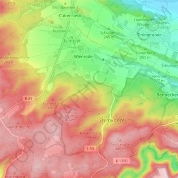
Name: Wienrode topographic map, elevation, terrain.
Average elevation: 316 m
Minimum elevation: 153 m
Maximum elevation: 459 m
Other topographic maps
Click on a map to view its topography, its elevation and its terrain.
Derenburg
Deutschland > Sachsen-Anhalt > Blankenburg > Blankenburg
Derenburg, Blankenburg, Landkreis Harz, Sachsen-Anhalt, 38895, Deutschland
Average elevation: 173 m
Holzberg
Deutschland > Sachsen-Anhalt > Blankenburg
Holzberg, Blankenburg, Landkreis Harz, Sachsen-Anhalt, 38889, Deutschland
Average elevation: 444 m