Geolocate

Vierzon topographic map

Click on the map to display elevation.

About this map
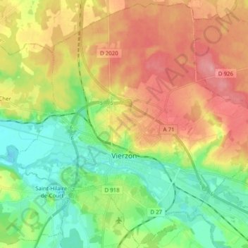
Name: Vierzon topographic map, elevation, terrain.

Location: Vierzon, Cher, Centre-Val de Loire, Metropolitan France, 18100, France (47.18422 2.00099 47.28581 2.15421)

Average elevation: 137 m

Minimum elevation: 91 m

Maximum elevation: 194 m

Other topographic maps

Click on a map to view its topography, its elevation and its terrain.

Les Houards

France > Centre-Val de Loire > Cher > Le Grouzeau

Average elevation: 157 m

Ivry

France > Centre-Val de Loire > Cher > Vasselay

Average elevation: 159 m

Chavignol

France > Centre-Val de Loire > Cher > Amigny

Average elevation: 282 m

La Garde de Dieu

France > Centre-Val de Loire > Cher > Culan

Average elevation: 276 m

Crux

France > Centre-Val de Loire > Cher > Villequiers

Average elevation: 196 m

Bertrix

France > Centre-Val de Loire > Cher > Clémont

Average elevation: 148 m

Gear up for your next adventure:

🧥Waterproof Hiking Jacket - Protect yourself from rain and wind while hiking
💡Solar Camping Lamp - Eco-friendly lighting for campsites
🧢Sun Hat - Wide-brim hat for sun protection
🥾Mountain Hiking Boots - High-traction boots for rocky terrain
🥘Camping Cookware Set - Compact nesting pots and pans for trail cooking

As an Amazon Associate, this site earns from qualifying purchases at no extra cost to you.