
Thank you for supporting this site ❤️
Make a donation
Make a donation
Gear up for your next adventure:
As an Amazon Associate, this site earns from qualifying purchases at no extra cost to you.
Nalchha topographic map
Click on the map to display elevation.
Thank you for supporting this site ❤️
Make a donation
Make a donation
Gear up for your next adventure:
As an Amazon Associate, this site earns from qualifying purchases at no extra cost to you.
About this map
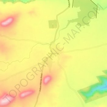
Name: Nalchha topographic map, elevation, terrain.
Location: Nalchha, Dhar Tahsil, Dhar, Madhya Pradesh, 454010, India (22.40053 75.39043 22.44053 75.43043)
Average elevation: 592 m
Minimum elevation: 441 m
Maximum elevation: 702 m
Thank you for supporting this site ❤️
Make a donation
Make a donation
Gear up for your next adventure:
As an Amazon Associate, this site earns from qualifying purchases at no extra cost to you.