
Thank you for supporting this site ❤️
Make a donation
Make a donation
Gear up for your next adventure:
As an Amazon Associate, this site earns from qualifying purchases at no extra cost to you.
Raufarhöfn topographic map
Click on the map to display elevation.
Thank you for supporting this site ❤️
Make a donation
Make a donation
Gear up for your next adventure:
As an Amazon Associate, this site earns from qualifying purchases at no extra cost to you.
About this map
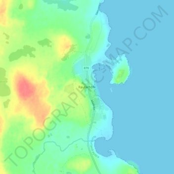
Name: Raufarhöfn topographic map, elevation, terrain.
Location: Raufarhöfn, Norðurþing, Northeastern Region, 675, Iceland (66.43300 -15.97094 66.47300 -15.93094)
Average elevation: 13 m
Minimum elevation: -2 m
Maximum elevation: 55 m
Thank you for supporting this site ❤️
Make a donation
Make a donation
Gear up for your next adventure:
As an Amazon Associate, this site earns from qualifying purchases at no extra cost to you.