
Make a donation
Gear up for your next adventure:
As an Amazon Associate, this site earns from qualifying purchases at no extra cost to you.
L'Aquila topographic map
Click on the map to display elevation.
Make a donation
Gear up for your next adventure:
As an Amazon Associate, this site earns from qualifying purchases at no extra cost to you.
L'Aquila
Close to the highest of the Apennine summits, L'Aquila is positioned at an elevation of 721 metres (2,365 ft) in the Valley of the Aterno-Pescara, situated between four mountain peaks above 2,000 metres (6,600 ft).
Make a donation
Gear up for your next adventure:
As an Amazon Associate, this site earns from qualifying purchases at no extra cost to you.
About this map
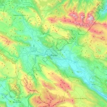
Name: L'Aquila topographic map, elevation, terrain.
Location: L'Aquila, Abruzzo, Italy (42.17658 13.17723 42.53155 13.65410)
Average elevation: 1,192 m
Minimum elevation: 510 m
Maximum elevation: 2,844 m
Make a donation
Gear up for your next adventure:
As an Amazon Associate, this site earns from qualifying purchases at no extra cost to you.
Other topographic maps
Click on a map to view its topography, its elevation and its terrain.