
Make a donation
Gear up for your next adventure:
As an Amazon Associate, this site earns from qualifying purchases at no extra cost to you.
Lohrsdorf topographic map
Click on the map to display elevation.
Make a donation
Gear up for your next adventure:
As an Amazon Associate, this site earns from qualifying purchases at no extra cost to you.
About this map
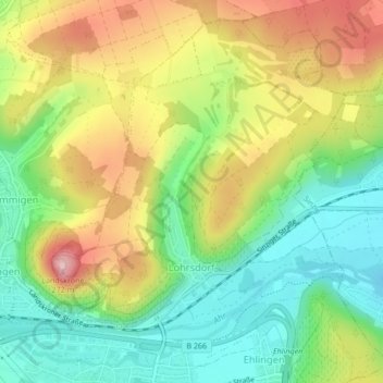
Name: Lohrsdorf topographic map, elevation, terrain.
Average elevation: 141 m
Minimum elevation: 64 m
Maximum elevation: 243 m
Make a donation
Gear up for your next adventure:
As an Amazon Associate, this site earns from qualifying purchases at no extra cost to you.
Other topographic maps
Click on a map to view its topography, its elevation and its terrain.
Landskrone
Deutschland > Rheinland-Pfalz > Landkreis Ahrweiler > Bad Neuenahr-Ahrweiler
Ahrschleife bei Altenahr | An der Teufelsley | Aremberg | Bausenberg | Dachsbusch | Hohe Acht | Hürs-Nück | In der Burwies | Laacher See | Landskrone | Lehrenkopf | Meirother Kopf und Tiefenstein | Mündungsgebiet der Ahr | Nürburg | Quiddelbacher Höhe / Nürburgring | Olbrück | Perler Kopf | Quellgebiet…
Average elevation: 129 m
Neuenahrer Berg
Deutschland > Rheinland-Pfalz > Landkreis Ahrweiler > Bad Neuenahr-Ahrweiler
Average elevation: 213 m