
Make a donation
Gear up for your next adventure:
As an Amazon Associate, this site earns from qualifying purchases at no extra cost to you.
Mera Peak topographic map
Click on the map to display elevation.
Make a donation
Gear up for your next adventure:
As an Amazon Associate, this site earns from qualifying purchases at no extra cost to you.
Mera Peak
In September 2017, Hari Budha Magar summited Mera Peak, in doing so he became the first ever double above-knee amputee to climb a mountain over 6,000m in altitude.[9]
Make a donation
Gear up for your next adventure:
As an Amazon Associate, this site earns from qualifying purchases at no extra cost to you.
About this map
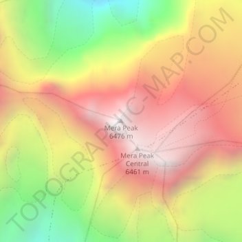
Name: Mera Peak topographic map, elevation, terrain.
Location: Mera Peak, Bung, Mahakulung, Solukhumbu, Province #1, Nepal (27.70979 86.86861 27.70989 86.86871)
Average elevation: 5,709 m
Minimum elevation: 4,779 m
Maximum elevation: 6,450 m
Make a donation
Gear up for your next adventure:
As an Amazon Associate, this site earns from qualifying purchases at no extra cost to you.