
Make a donation
Gear up for your next adventure:
As an Amazon Associate, this site earns from qualifying purchases at no extra cost to you.
Góra Kalwaria topographic map
Click on the map to display elevation.
Make a donation
Gear up for your next adventure:
As an Amazon Associate, this site earns from qualifying purchases at no extra cost to you.
Góra Kalwaria
The layout of a new town was subordinated to the celebrations of the Way of the Cross. It consisted of two main streets forming a Latin cross with a church (Pilate's court) at the intersection. The plan followed medieval plans meant to resemble ancient Jerusalem. The Baroque composition extended far beyond the former village. The axes led to three monastery complexes: Bernardines, Piarists and Dominicans and the Saint Cross Church; their symmetrical distribution additionally emphasised the cross-shaped layout. The monastery of Oratorians, afterwards Friars of Holy Communion, supplemented the Saint Cross Church and enacted the ceremonies conducted in the sanctuary. Besides this, south-west from the town, two more monastery complexes were erected: Marians and Dominican Sisters, accessible from a side road which was connected to the main one next to the Dominicans Monastery. An attempt to emulate the ideal layout of Jerusalem had to be adjusted to local conditions. Not all the elements of the plan could be easily recreated, due to the local topography. For instance, Golgota Hill, which should have its location in the bottom left portion of the plan, could not be placed next to the embankment due to the lack of sufficient space for the required chapels there. The arrangement extended far into the open landscape, with numerous chapels situated in the surrounding forest. The longer axis, which used the existing ravine as a part of the terrain configuration, was defined with Kalwaryjska Street and the market square, its prolongation continued as the local road to Piaseczno.
Make a donation
Gear up for your next adventure:
As an Amazon Associate, this site earns from qualifying purchases at no extra cost to you.
About this map
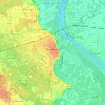
Name: Góra Kalwaria topographic map, elevation, terrain.
Average elevation: 101 m
Minimum elevation: 83 m
Maximum elevation: 125 m
Make a donation
Gear up for your next adventure:
As an Amazon Associate, this site earns from qualifying purchases at no extra cost to you.
Other topographic maps
Click on a map to view its topography, its elevation and its terrain.